Fiscal Year 2020 NOAA Office of Ocean Exploration and Research
Federal Funding Opportunity Grants
September 4, 2020
Through the Ocean Exploration Fiscal Year (FY) 2020 Funding Opportunity, the NOAA Office of Ocean Exploration and Research (OER) selected five projects for financial support totaling approximately $2.4 million. For the FY 2020 competition, OER solicited proposals for ocean exploration that may inform ocean-related segments of the U.S. economy, also referred to as the Blue Economy, and projects that support Seabed 2030 goals, an international collaboration to fully map the global ocean by the year 2030. Priorities were focused on interdisciplinary baseline characterizations of unknown or poorly known areas of the ocean, processes, and resources; discovery and initial characterization of underwater cultural heritage; and technological innovation to advance ocean exploration objectives. The supported projects are described below.
Coordinated Simultaneous Physical-Biological Sampling by ADCP-Equipped Ocean Gliders
Principal Investigator: Wu-Jung Lee, University of Washington
Dates: August 2021 (10 days)
Despite their critical role in marine ecosystems, the economy, and our food supply chain, midtrophic-level animals like zooplankton and small fish, which are both predators and prey, are among the least understood animals in the ocean. Currently, researchers lack the tools they need to effectively study these animals at large spatial and temporal scales. To address this gap, this research team will develop new ways for long-term, large-scale data collection related to these important resources.
Operating in Juan de Fuca Canyon offshore Washington, the team will equip autonomous underwater gliders with acoustic Doppler current profilers (ADCPs). These instruments are usually used to measure the speed and direction of ocean currents, but they can also be used to detect and quantify animals as they move through the water column. The team will demonstrate how ADCPs can be used to simultaneously collect needed physical and biological data in a manner that is easier and cheaper than current ship-based efforts.
This project will deliver broadly adoptable ways to collect, process, and analyze data about these midtrophic animals and has the potential to greatly advance the study of living marine resources. By providing a more complete picture of the ecosystem, these new technologies and processes will better enable resource managers to make policy decisions that support sustainable resource management.
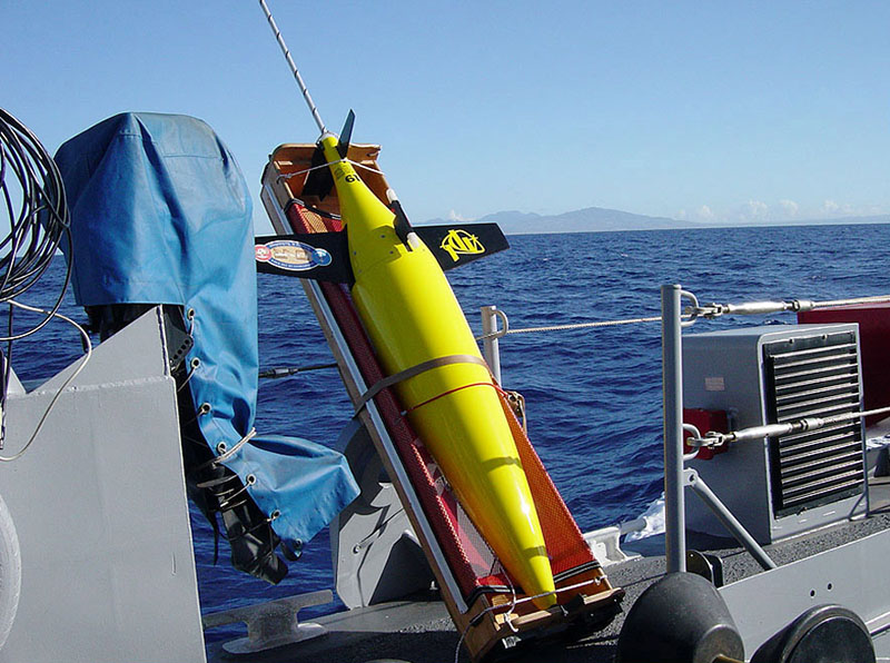
Seagliders like the one shown here will play a central role in this project. Image courtesy of Applied Physics Lab, University of Washington. Download larger version (jpg, 549 KB).
Deepwater AUV Surveys of WWII U.S. Cultural Assets in the Saipan Channel
Principal Investigator: Eric Terrill, Scripps Institution of Oceanography, University of California San Diego
Dates: January 20-February 8, 2021 (20 days)
During World War II, U.S. airbases in the Northern Mariana Islands played a pivotal role in the war outcome by supporting thousands of B-29 aircraft flying long-range bombing missions to Japan. Several military planes crashed in nearby waters. The research team will explore the waters off Tinian and Saipan to locate and document U.S. planes (mostly B-29s) lost during the war.
Their work will build on existing data, most notably U.S. Navy and NOAA seafloor maps that led to the discovery of a B-29 by researchers on NOAA Ship Okeanos Explorer in 2016. The team will use state-of-the-art scientific methods and technologies, including shipboard systems; a fleet of autonomous underwater vehicles (AUVs) equipped with side-scan sonars, light imaging capabilities, a sub-bottom profiler, and multibeam sonar; and a remotely operated vehicle to conduct archeological surveys, map the seafloor in the region, and characterize the neighboring seabed habitat.
This project will provide an inventory of aircraft crash sites off Tinian and Saipan and data for site management and preservation; advance the efficiency, accuracy, and cost effectiveness of deepwater archaeology; and promote an increased awareness of maritime cultural heritage through technologies that make underwater sites remotely accessible (e.g., 3-D models). Finally, it will document and honor the final resting place of 76 U.S. service members who lost their lives in these waters.
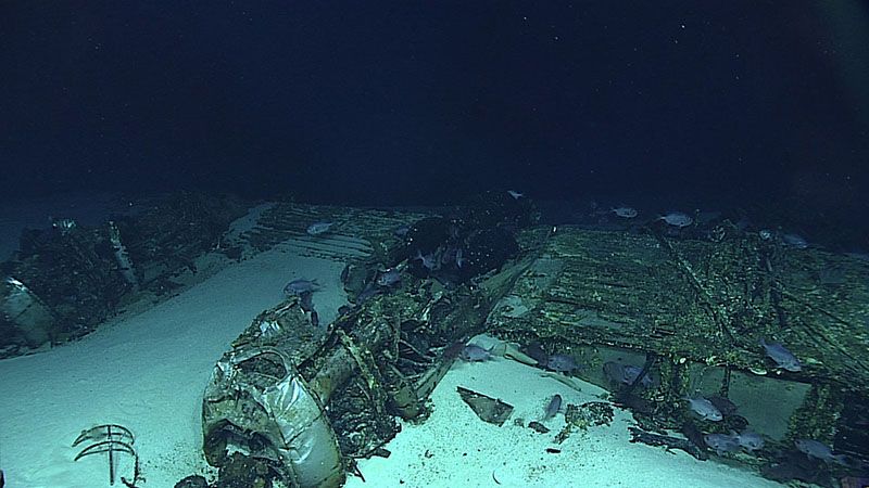
This B-29 Superfortress was found near Tinian during an expedition on NOAA Ship Okeanos Explorer in 2016 and will be revisited as part of this project. Image courtesy of NOAA Office of Ocean Exploration and Research, 2016 Deepwater Exploration of the Marianas. Download larger version (jpg, 765 KB).
Discovering the Submerged Prehistory of the Alpena-Amberley Ridge in Central Lake Huron
Principal Investigator: John O'Shea, University of Michigan
Dates: June through August, 2020, 2021 (45 days)
Now submerged beneath Lake Huron, the Alpena-Amberley Ridge was once a dry land corridor that divided the lake in two. Researchers have found evidence of human occupation on the ridge dating back 10,000 years, including stone hunting structures that are among the oldest dated examples on the planet. Building on previous work, the research team will explore the ridge, part of which lies in the Thunder Bay National Marine Sanctuary.
This project has three primary components: mapping, site identification/documentation, and model assessment. The research team will produce a 3-D representation of the ancient landscape and its environment and use mapping data to target features of potential archaeological interest for investigation with a remotely operated vehicle and by scuba-trained archaeologists. They will also evaluate a model designed to predict the location of underwater cultural resources in the region.
This project has the potential to greatly enhance our understanding of early human occupation of the Great Lakes region and provide important information to aid in managing the unique cultural resources preserved beneath Lake Huron. In addition, it will be incorporated into Science in the Sanctuary, a local public school program, and serve as the basis for a traveling museum exhibit highlighting the archaeological finds and the underwater landscape of the Alpena-Amberley Ridge.
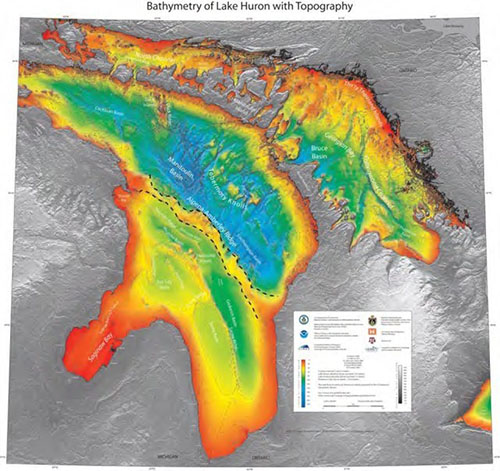
The location of the Alpena-Amberley Ridge (shown here with dotted lines) can be seen in the high-resolution bathymetry of Lake Huron. Image adapted from NOAA National Centers for Environmental Information. Download larger version (jpg, 314 KB).
Paleolandscapes, Paleoecology, and Cultural Heritage on the Southern California Continental Shelf
Principal Investigator: Amy Gusick, Natural History Museum of Los Angeles County
Dates: June-July 2021, February-May 2022 (18 days)
Archaeological evidence found at coastal sites in Southern California suggests the region was once populated by early maritime hunter-gatherers and that similar sites, inundated by sea-level rise approximately 20,000-8,000 years ago, are likely to also exist on the seafloor. Building off their previous work, the research team will search for and study ancient landforms, unique environmental features, and archaeological sites on the submerged landscape of the Southern California continental shelf.
Using both traditional (sub-bottom sonar) and emerging methods (controlled source electromagnetic technology), the team will map the seafloor in the project area to identify features that may have once attracted occupation, like ancient channels and estuaries and tar seep deposits. They will use this information to target sites for exploration and sample collection with a remotely operated vehicle.
The researchers will incorporate findings into existing maps and models to improve understanding of the project area’s ancient landscape, how it changed over time, and the reasons for those changes, as well as the importance of the region in the history of human migration to the Americas. Findings will also be used to inform the protection of the region’s archaeologically and biologically sensitive landscapes.
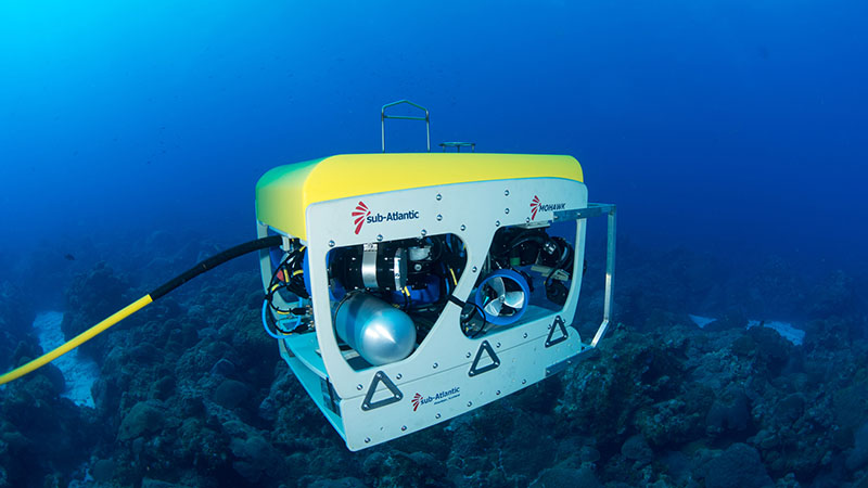
The Mohawk remotely operated vehicle shown here will be used to search for archaeological sites on the seafloor off Southern California. Image courtesy of NOAA Office of National Marine Sanctuaries/Flower Garden Banks National Marine Sanctuary. Download larger version (jpg, 1.4 MB).
Submarine Ring of Fire: Hydrothermal Hunt in the Northern Mariana Back-Arc
Principal Investigators: Carol Stepien, NOAA Pacific Marine Environmental Laboratory/David A. Butterfield, Joint Institute for the Study of the Atmosphere and Ocean (University of Washington and NOAA Pacific Marine Environmental Laboratory)
Dates: February 1, 2021-April 1, 2021 (48 days)
Hydrothermal vents support abundant life despite their extreme conditions and produce critical minerals, making them particularly interesting and important to explore. Vents have been documented in the southern and central parts of the Mariana back-arc as part of a larger investigation of the region, but little is known about the northern part. To complete the investigation, the research team will explore the northern half of the Mariana back-arc to identify and characterize active hydrothermal vent sites and their biological and mineral resources.
During the first leg of the two leg expedition, the team will use ship-based systems and an autonomous underwater vehicle with a towed conductivity, temperature, and depth (CTD) instrument package to search for, identify, and map new vent sites. During the second leg, they will use a remotely operated vehicle (ROV) to visually explore the sites and collect geological, chemical, and biological samples. Video of the ROV dives will be streamed live online with commentary.
This expedition will expand our understanding about ecosystem connectivity within and beyond the Mariana region and about how geology and geochemistry shape biodiversity. In addition, it will directly support the management and stewardship of resources within the nearby Mariana Trench Marine National Monument.
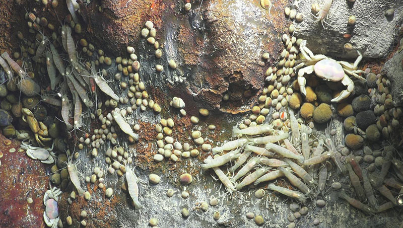
These hydrothermal vents in the Hafa Adai vent field were explored by the researchers in 2016. Image courtesy of the NOAA Pacific Marine Environmental Laboratory/Schmidt Ocean Institute. Download larger version (jpg, 240 KB).