Figure 1. Appearing as small white crescents on the rocks, fragile and delicate fans in the genus Corallium are clearly "seen" by the laser line scanner. Click image for larger view and image credit.
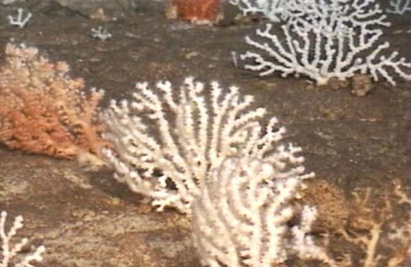
Figure 2. An older side image of the genus Corallium taken several years ago from a remotely operated vehicle. Click image for larger view and image credit.
Testing the Laser Line Scanner
November 9, 2006
Christopher Kelley
Hawaii Undersea Research Laboratories
The Operation Laser Line 2006 cruise aims to test the application of new technology — a laser line scanner — for use in identifying and mapping deep-water coral and fish habitats in Hawaii. As with testing any new instrument, our day can begin with “wow” and “look-at-that” exclamations of amazement, and then turn suddenly into the “shucks” and “darns” of disappointment when a technical problem interrupts the operations. It was that kind of day for the scientists and engineers on this cruise.
Everything began fine with the ship’s crew and Scientific Applications International Corporation engineers successfully deploying the scanner in the middle of the Pailolo Channel, between the islands of Molokai and Maui. The ship, with scanner in tow, began surveying the sea floor along the northern tip of Maui toward the first study site. On the way, we observed fish, an impressive bed of curly-cued wire corals (that are literally no thicker than wire), and right at the end, an aggregation of sea urchins. The bottom was mostly sediment and a bit boring, but what the heck: we were seeing and creating near-photographic maps of the sea floor and its inhabitants with a laser! Very exciting!
We got to the study site at the northern end of the channel around 6:30 in the morning and started right in on the first survey tracks. Unlike the sea floor we observed during our transit, the sea floor here was rocky, with lots of low-relief carbonate outcrops, cobbles, and boulders. The depth was around 250 m (more than 800 ft). We were looking at the remains of an old coral reef that thousands of years ago was at, or just below, the surface. Although the reef-building corals and algae that created them are long since dead, their carbonate skeletons persisted and (at these depths) serve as stable platforms upon which an entirely new and different community of other corals, called gorgonians, attach and grow.
We were hoping the laser line scanner would have high enough resolution to “see” some of these animals, called sea fans, and weren’t disappointed. Appearing as small white crescents on the rocks, fragile and delicate fans in the genus Corallium clearly showed up on the first two tracks (fig. 1). Remember, we are looking straight down on them; and we are looking at their top edge. Figure 2 shows you an older side image of this type of coral taken several years ago from a remotely operated vehicle (ROV).

Figure 3. The species in this laser line scan picture may be a primnoid. Click image for larger view and image credit.
Unfortunately, right after completing two tracks, the scanner stopped working. Engineers quickly determined that they had to pull it up on deck, which they did, and that is where it remained for the rest of the morning. And afternoon. And evening. Finally, they fixed the problem and back it went into the water. The survey was re-started at 10:30 that night. Two and a half more tracks were completed successfully before the ship had to break off to head for other study sites. While we didn’t complete the planned survey, we were excited to discover another dense bed of different gorgonians near the northern end of the channel that appeared as dark crescents on the laser scan. We’re not sure which species we were looking at yet, but we suspect they are in a group called primnoids (fig. 3). We also found more Corallium and wire corals.
We were disappointed in not being able to complete the survey at that first study site, but we did confirm the presence of deep-water gorgonians in the area and the ability of the laser line scanner to detect and map them.
Sign up for the Ocean Explorer E-mail Update List.


