April 20 - May 26, 2010
As with many underwater endeavors, our project in the Sea of Cortez in 2010 had both pleasant and unpleasant surprises. First, the good news. The amount of data that we were able to collect is simply daunting. Over 40 square kilometers of remotely sensed imagery of the entire nearshore environment off of the western shore of Isla Espíritu Santo, 25 targeted dive locations identified from that imagery with 76 individual targets to explore. The data from those 25 individual dives include ten soil cores samples and dozens of bulk samples. Now, the unpleasant surprise. Although we had intended on concurrently collecting both side scan sonar and subbottom profiler information, the subbottom profiler malfunctioned the first day that we were out to sea. Because Mexico has very rigid regulations concerning the importing and exporting of scientific equipment, we were unable to have a replacement part shipped to us. The effect this had on the overall project was that we were unable to view what was beneath the marine sediment; therefore, positively identifying buried paleoriver channels or shell middens was impossible from the side scan imagery alone. However, images from the side scan sonar were very useful in identifying areas with probable paleorivers channels and we were able to identify areas of positive and negative relief. These areas were then ground truthed during our diving phase.

The research team in front of Covacha Babisuri, a late Pleistocene-age archaeological site inside of a rockshelter on Isla Espiritu Santo. The site was discovered and excavated by Harumi Fujita. From left: Loren Davis, Michael Glassow, Andy Hemmings, Harumi Fujita, Kaya Chotard, Amy Gusick, Clint Nelson, and Eric Hessel. Image courtesy of Amy Gusick, Sea of Cortez 2010 Expedition. Download image (jpg, 130 KB).
The remote sensing phase of the project was extremely successful. The shear amount of data that we were able to collect was possible due to the dedication of both the scientific crew and the crew of the M/V Don Jose. The eight days spent on the Don Jose were dedicated to collection of continuous lines of side scan sonar data. Each day that we collected this data, we continually processed the sonar lines, eventually creating a mosaic image that represented the entire submerged landscape, from 5 to 250 feet deep, off of the west side of Isla Espíritu Santo. This imagery was merged with the terrestrial landscape of the island in order to identify areas where paleoriver channels extended onto the submerged landscape, as well as areas that presented features indicative of the types of prehistoric coastal environments that we were targeting for scuba exploration.

Side scan sonar media showing an area of rock fall along with a interesting linear rock formation that may be an ancient fishing weir. Areas like this one were targeted for further exploration during the diving phase. Image courtesy of Amy Gusick, Loren Davis, Sea of Cortez 2008 Expedition. Download image (jpg, 130 KB).
The scuba exploration and testing phase was also successful. From the mosaic image of the submerged landscape, we identified locations that presented clusters of features that warranted underwater survey and testing. The data collected from the dives onto these features include ten soil cores samples and dozens of bulk samples collected from test pits. These data are currently being processed for cultural material and for environmental markers such as terrestrial soil. The immediate result of the scuba exploration and testing, however, was a broader understating of the landscape surrounding Isla Espíritu Santo. From our observations and testing in the field we have been able to identify submerged coastal landscapes, including areas with features such as beach ridges. We have tentatively identified two new submerged paleoriver channels, one of them in Dispensia Bay, where a late Pleistocene archaeological site is located on the terrestrial portion of island. Important to understanding environmental changes occurring on the island are the relic coral beds we also identified around Isla La Ballena and Dispensia Bay. These types of marine landscape formations are beneficial for identifying changes to landscape over the past 15,000 years, as these coral reefs can only grow in certain depths and conditions. As sea level was rising, these reefs would grow in specific conditions, and then die when they were too deeply inundated. Relic coral reefs are also an important resource for the ancient hunter-gatherers who inhabited Isla Espíritu Santo. Indeed, excavations at terrestrial sites have uncovered numerous coral tools that were used in the daily activities of the island inhabitants.

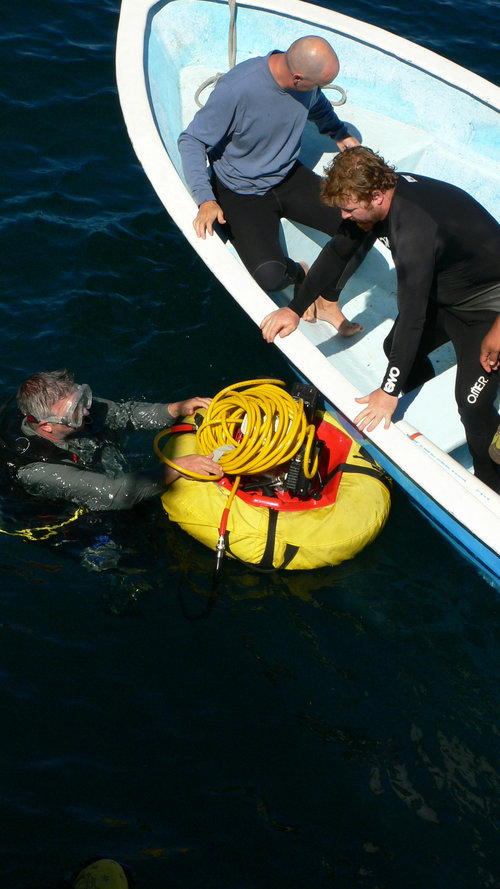
Clint Nelson hands Loren Davis the motor and the airhose for the airlift device. The motor is attached to an air compressor that floats on the surface and pushes air down the hose into a PVC pipe that will suction material off the sea floor. Image courtesy of Amy Gusick, Loren Davis, Sea of Cortez 2008 Expedition. Download larger version (jpg, 1.4 MB).
Additionally, we have identified areas where the layer underlying the marine sediment is solid shell or solid coral, and we have identified variations in the composition of the sediment within and outside of the bays on the island. This type of information is particularly important to developing a methodology for conducting prehistoric underwater archaeology in this region of Baja California. Conditions for underwater work can vary greatly and researchers working in the field do need to be innovative and able to develop methods that are appropriate for the given project conditions. The more robust sediment and substrate information collected will guide future testing regimes, particularly for conducting sediment coring.

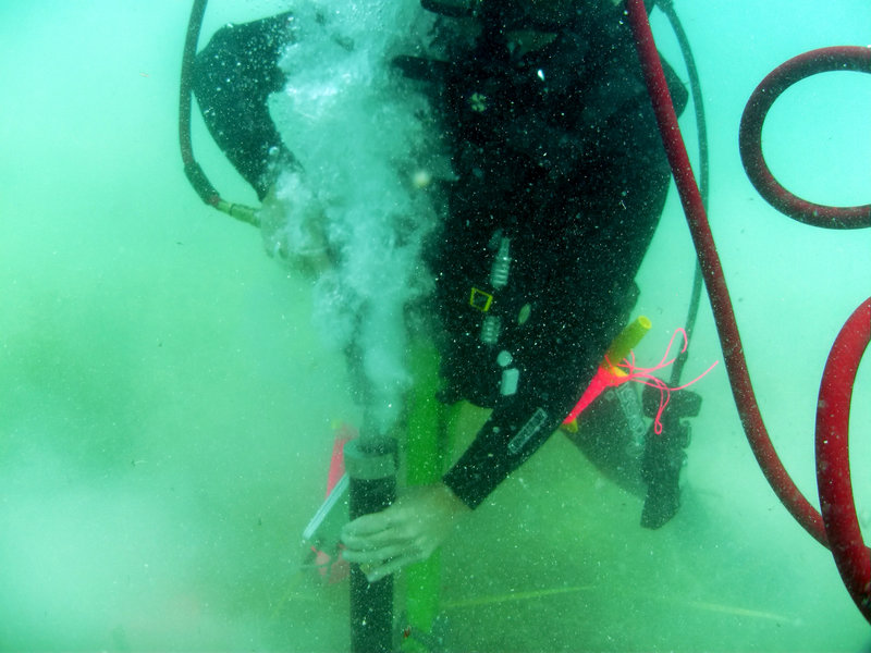
Diver operating the pneumatic corer. The airgun has a specialized head that holds a PVC pipe. The device is attached to a surface supplied airsource. Image courtesy of Amy Gusick, Loren Davis, Sea of Cortez 2008 Expedition. Download larger version (jpg, 7.2 MB).
All of the discoveries made during our 2010 season are integral for building the knowledge base necessary to conduct efficient survey and to utilize the proper methods and tools for sample collection. Because very little is known about this area of Baja California, it is important to establish an understanding of the changes to the local geomorphological and environmental characteristics that have occurred over the past 15,000 years. By systematically narrowing down our study areas to those locales that present both features indicative of past human habitation and conditions that will allow for testing, we move one step closer to identifying the submerged late Pleistocene landscape that will aid in our quest to evaluate coastal migration and gain a more comprehensive understanding of submerged sites, thereby clarifying New World archaeological chronology in general.